14 walks and hikes near Auckland
Get outside and explore pockets of wild nature around Auckland city

Auckland is a great place for hiking, with nature trails covering everything from coastal views, to bush walks and summit climbs.
Sandwiched between two harbours, Auckland’s urban sprawl spills from the North Shore’s golden beaches, to the West Coast’s bush-clad hills and the quiet bays of South Auckland.
Set off in any direction and you’ll hit one of Auckland’s 28 regional parks or find yourself on an isolated beach. You can be walking in nature in less than an hour’s drive from the centre of Auckland.
Born and raised in rural New Zealand, I’m always keen to get outdoors and get lungfuls of fresh air.
Here are my top hikes near Auckland, where I go for my nature fix.
jump ahead.
Island walks near Auckland
Some of my favourite walks in Auckland are on islands in the Waitematā Harbour.
You have to pay for the ferry to get there, but when you take the cost of petrol into account, it might not be much more than driving to hikes an hour out of Auckland.
These islands have the added romanticism of being largely cut off from the city. With pristine beaches and few predators, they are as good for swimming and bird spotting as they are for walking.
1. Rangitoto Island Summit Hike


// 7 kilometres
// 2 hours return
// DOC track details
// See the ferry timetable and prices here
Rangitoto Island is a fixture of the Auckland skyline. From almost anywhere in the city, if you look out to sea you’ll see the perfect cone of Rangitoto rising out of the harbour.
Climbing to the summit of Rangitoto is an easy Auckland day walk.
Catch the 25-minute Fullers ferry from Britomart ($53 return for an adult) and step onto the volcanic shores. The scrubby bush and porous black rocks give Rangitoto a wild and remote feel, despite being so close to Auckland.
The climb to the summit is gentle, and from the top you have incredible views across the lava fields and pōhutukawa forest out to the harbour and Auckland skyline.
Because this walk is quick and easy, you can add on a walk around the base of Rangitoto Island, even popping across the causeway to the adjacent Motutapu Island for a longer day out.
Walking around the base of Rangitoto you’ll quickly get away from the crowds headed to the summit, and it will feel much more like a deserted island.
I love the tiny retro baches tucked up against the volcano slopes — if you’re lucky, you can book a night in one on Bookabach.
Just make sure you’re back in time for the ferry. The last departure is usually 3.30 or 4pm.
2. Te Ara Hura, Waiheke Island

// Matiata ferry to Oneroa is 5.5 kilometres via the coast
// 2 hours
// Reward yourself with some Island Gelato after
Waiheke Island is an epic place for walks near Auckland, but its trails still fly under the radar. Hiking on Waiheke is a great way to see more of the island than just the vineyards.
Te Ara Hura is a network of trails that loop right around Waiheke Island. It’s about 100 kilometres of trails in total, so if you’re really committed you could turn it into a multi day trek.
You can also choose to walk sections of Te Ara Hura, covering areas that are easy to get to.
My favourite section runs from the ferry terminal to Oneroa.
You can start walking straight off the ferry, heading clockwise (turn left out of the terminal) around the coast of Waiheke until you reach Oneroa.
The track is generally easy to follow and it’s basically impossible to get lost — you’re never far away from roads and houses.
There are still some pretty sections with quiet bays and regenerating bush, though. And, you get to finish up on one of the best beaches in Auckland — the perfect place for a post walk dip.
Oneroa is also a great place to hang out for a while, and you can complete the loop by strolling back to the ferry via the forest trail parallel to the road.
Check out this detailed track map for more information.
3. Motuihe Island Walks

// Walking trails of around 3 hours
// Red Boats ferry $43 per person return
// DOC trail information
Motuihe Island sits between Motutapu and Waiheke island — you might have seen it if you’ve ever caught the ferry across to Waiheke.
It’s a bit of a hidden gem. As well as having some of Auckland’s best beaches, Motuihe Island has some epic walking trails.
There’s a network of tracks around the island. The Bald Knob Track takes around 2-3 hours return from the wharf, making it a good half-day hike option.
The island is still regenerating, so it’s not fully covered in bush, but you’ll still see native birds flitting around and get panoramic views of the Hauraki Gulf.
The Red Boats run a ferry over summer, dwindling to weekend trips later in the year and pausing over winter.
There is a DOC campground on the island, so if you’re feeling adventurous, you could even spend the night on the island.
Central Auckland walks
The centre of Auckland is peppered with volcanic cones, which make for great walks to epic views.
4. Mt Saint John Path (Te Kōpuke / Tītīkōpuke)
// 1 kilometre
// 30 minutes
Although Mount Eden/Maungawhau is the most famous volcanic cone in Auckland — and the most impressive, with its deep inverted crater — my personal favourite is Mt Saint John (Te Kōpuke / Tītīkōpuke).
This maunga (mountain) is much quieter than Maungawhau, and feels a lot more overgrown and untouched. There’s rarely a lot of people here, unlike Mount Eden, so it’s a nice walk to do if you want a peaceful escape.
There is a short path up and around the crater, with views of Ōhinerau / Mt Hobson and Maungawhau / Mt Eden.
Terraces and food pits from when this volcano was used as a Māori pā are still visible — take care not to walk on them. You also shouldn’t walk into the crater, as it’s considered sacred. Just stick to the crater rim path.
I love doing this walk at sunset, as it’s high enough to give sunset views of the Waitakere Ranges and wider Auckland.
West Auckland walks
Many of the walking trails in the Waitakere trails are closed (as of September 2023) as a result of weather damage and catastrophic kauri dieback. Check this Auckland map to see what walks are open.
These trails are still open and are still some of my top bush walks near Auckland.
5. Omanawanui Track

// 1 hour 40 minutes
// 3.1 kilometres
// Get snacks from Alfred’s Huia Store
Omanawanui is one of the best coastal walks in Auckland.
Starting near Whatipu Beach, the track features a boardwalk, an epic lookout at the highest point, and lots of steps.
You’ll be tracing a path along the entrance to the Manukau harbour, with waves crashing onto rocks at the bottom of steep cliffs and gnarled native bush sheltering parts of the track.
Drive out to Whatipu Beach to get to the starting point of the track. There are two entry points, one from the road higher up the hill and the other from the carpark near the beach. You can start from either the top or the bottom — either way, you’ll be walking out and back.
The carpark at the bottom has more space, and if you start from there it’s also easier to explore Whatipu Beach after the walk. Starting from the carpark at the bottom also means you don’t have to walk the full track, just turn back whenever you’ve had enough.
But, if you start at the top of Whatipu Road to keep the view in front of you as you walk down the ridge.
6. Mercer Bay Loop Track

// 7.2 kilometres
// 3 hours
// Get snacks and coffee from the Piha Store
The Mercer Bay loop walk is one of the most scenic tracks in Auckland.
From regenerating coastal forest to spine-tingling views from the top of sheer cliffs, Mercer Bay packs a lot into a 45-minute walk.
Start at the end of Te Ahuahu Road, and set off in a clockwise direction from the path at the southern side of the car park.
[Update: The Comans Track is closed as of September 2023]
If you want a longer hike, carry on down the Comans Track to Karekare beach.
Return the same way — be warned it’s a long climb back up — and complete the rest of the Mercer Bay Loop. This takes around three hours, making it a decent half day hike.
7. Karamatura to Mount Donald Maclean Hike

// 11.6 kilometres
// 4 hours 30 minutes
Hiking up Mount Donald Maclean is a great day walk near Auckland city.
It takes about four hours to reach the summit of Mount Donald Maclean and hike back down. There are copious steps on the way but the reward at the top is excellent views of Manukau Harbour and beyond.
There’s also a lot of shade cover from the trees, so it’s not overly hot walking up.
Start the walk from Huia, from the Karamatura track carpark. You’ll walk through the peaceful Karamatura valley, to Karamatura Falls where you can go for a swim.
After the falls, the track starts to climb steeply to the Donald Maclean track. The track is well-formed, with boardwalks in places. Once you make it past the stairs it get a lot easier.
At the summit you’ll find wooden platforms with panoramic views that are well worth the hike up.
This track is getting pretty busy, what with so many others being closed, so try and get out there before 9am to skip the crowds. The carpark is usually full by 9.30am and completely packed by midday.
Walks and hikes north of Auckland
The east coast of the Auckland region is completely different to the west. Head north of Auckland and you’ll find white sand beaches and lush coastal forest.
8. Long Bay Coastal Walk

// 8 kilometres out and back
// 3 hours return
The Long Bay Coastal Walk follows the clifftops at Long Bay Regional Park.
The walk starts from the northern end of the carpark at Long Bay. Along the way you’ll have beautiful coastal views.
The path also passes through lush green farmland, and goes past a couple of beaches where you can swim.
There’s not much shade on the walk, so try and avoid doing it in the midday heat and sunshine.
On the way back, you can follow the coastline if the tide is low.
9. Tāwharanui Ecology Track Walk
Image by Brendan Bombaci
// 3.5 kilometres
// 1 hour
// Stop in Matakana for brunch on the way
Tāwharanui Regional Park is famous for its beaches, but it’s also a great spot for walking.
The trails in the park are gentle and meandering, with options that skirt around the coastline, down to hidden bays, or through the patch of regenerating native bush cradled in the low hills.
My favourite walk here is the Ecology Trail. In the tall nikau palms and sun-dappled bush, you get a small glimpse of what this area used to look like before it was razed.
The best part is spotting all of the birds. It’s a small wonderland in here, with tieke/saddlebacks flitting around, kaka screeching overhead, and even takahe making a ponderous appearance.
Walk the track slowly and stop when it’s quiet to hear the birdsong.
10. Goat Island Lookout Walk

// 3 kilometres return
// 1 hour 30 minutes
// Stop by the Leigh Sawmill Smoko Room for lunch after the walk
A gentle out and back walk, the Goat Island Lookout trail is a lovely coastal walk near Auckland.
The track passes through patches of coastal forest and along the low cliffs above Goat Island Marine Reserve. It’s mostly level, so it’s a gentle walk and the ocean views are great for clearing your head.
As an added bonus, you can stop by the marine reserve and go snorkelling in summer months.
11. Dome Valley Summit Track

// 6 kilometres out and back
// 3 hours return
The Dome Valley Summit Track is a nice solid tramping track near Auckland.
It takes about one hour to drive from the city to the trailhead, but it’s worth the mission if you want to get out into some bush and really stretch your legs.
Starting from a carpark right off state highway 1, you’ll climb to a nice lookout point and then from there continue through mature forest to the summit.
You can see out to the sea and catch glimpses of the Hen and Chicken islands, but otherwise the highlight of this track is being immersed in the forest.
The track is close to Matakana, so you can always swing by the village for lunch after as a treat.
East Auckland walks
12. Duder Regional Park Walk
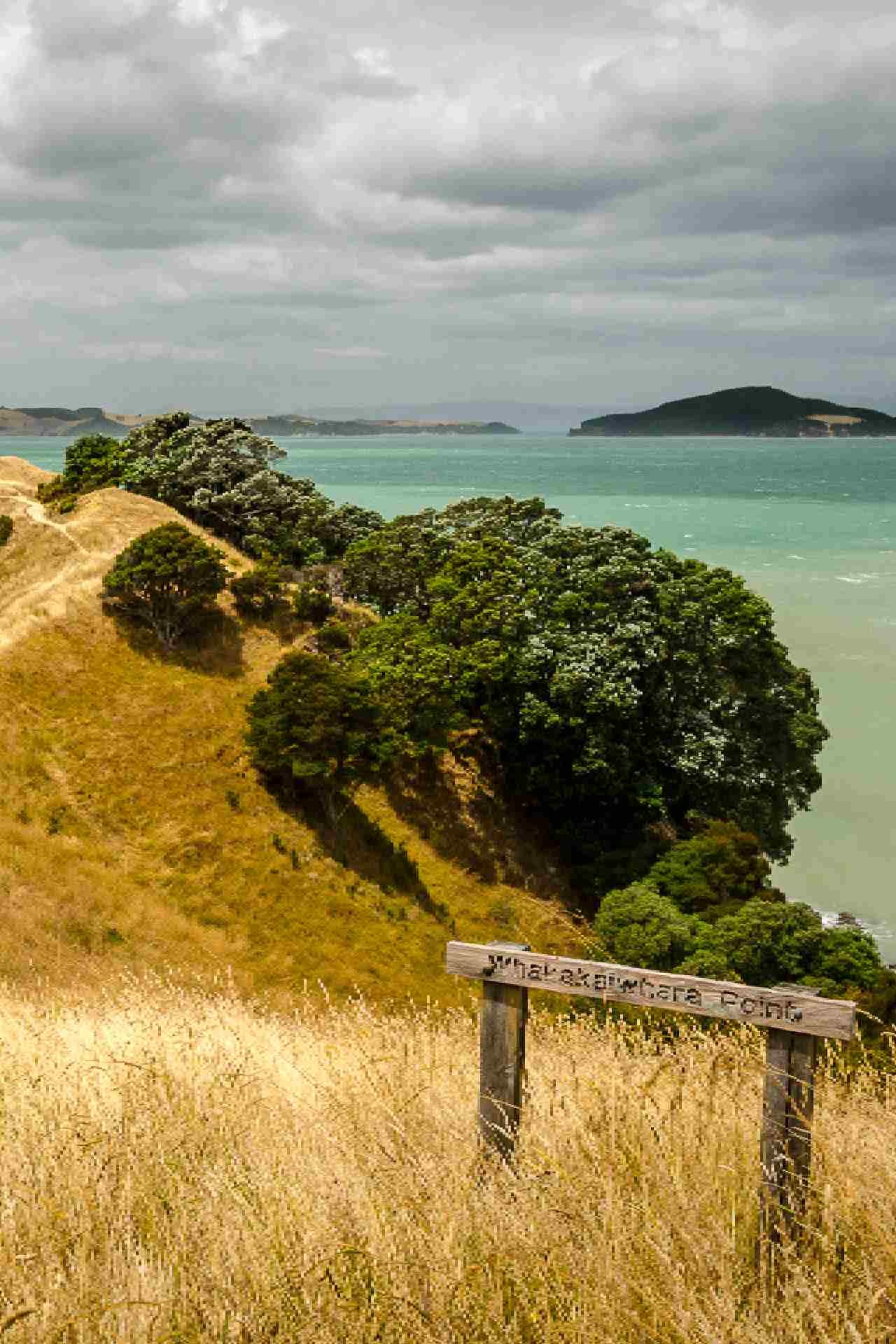
Photography by Stefen Marks
// 6 kilometres
// 1 hour 45 minutes
// Stop for coffee in Maraetai before the walk
Duder Regional Park is one of the prettiest places to walk in East Auckland. The knobbly finger of Duder peninsula juts out into the Hauraki Gulf, giving you water views on both sides.
The Duder Regional Park loop walk takes you across farmland and out to the tip of the peninsula, where the remnants of Whakakaiwhara Pā are located.
You’ll have to pick your own way across much of the grassy sections, but coloured posts will help guide you. It’s a gentle walk with plenty of wide open spaces and sweeping views.
13. Tawhitokino Beach Track
// 1 hour
// 2.5 kilometres return
// Track details
Tawhitokino Beach is one of Auckland’s best secret beaches. It's only accessible by foot, kayak or small boat, so it’s a great spot to escape the crowds.
You can only reach the beach at low tide, so make sure to check the tide times before you leave.
The Tawhitokino Beach walk starts at Waiti Bay on Kawakawa Bay Coast Road. The road down to Waiti Bay is narrow and winding, so take your time.
Waiti Bay beach itself is small and can get crowded on summer days, so it’s nothing special. But if you can walk along the inland track to reach Tawhitokino, you will be rewarded with a much more scenic and quiet beach with white sand and pohutakawa trees.
The coastal walk to Tawhitokino is backed by farmland and regenerating bush.
From the carpark to the beach takes around 30 minutes. You’ll need to walk over rocks and up a few sets of stairs.
14. Wairoa Dam Lookout Loop
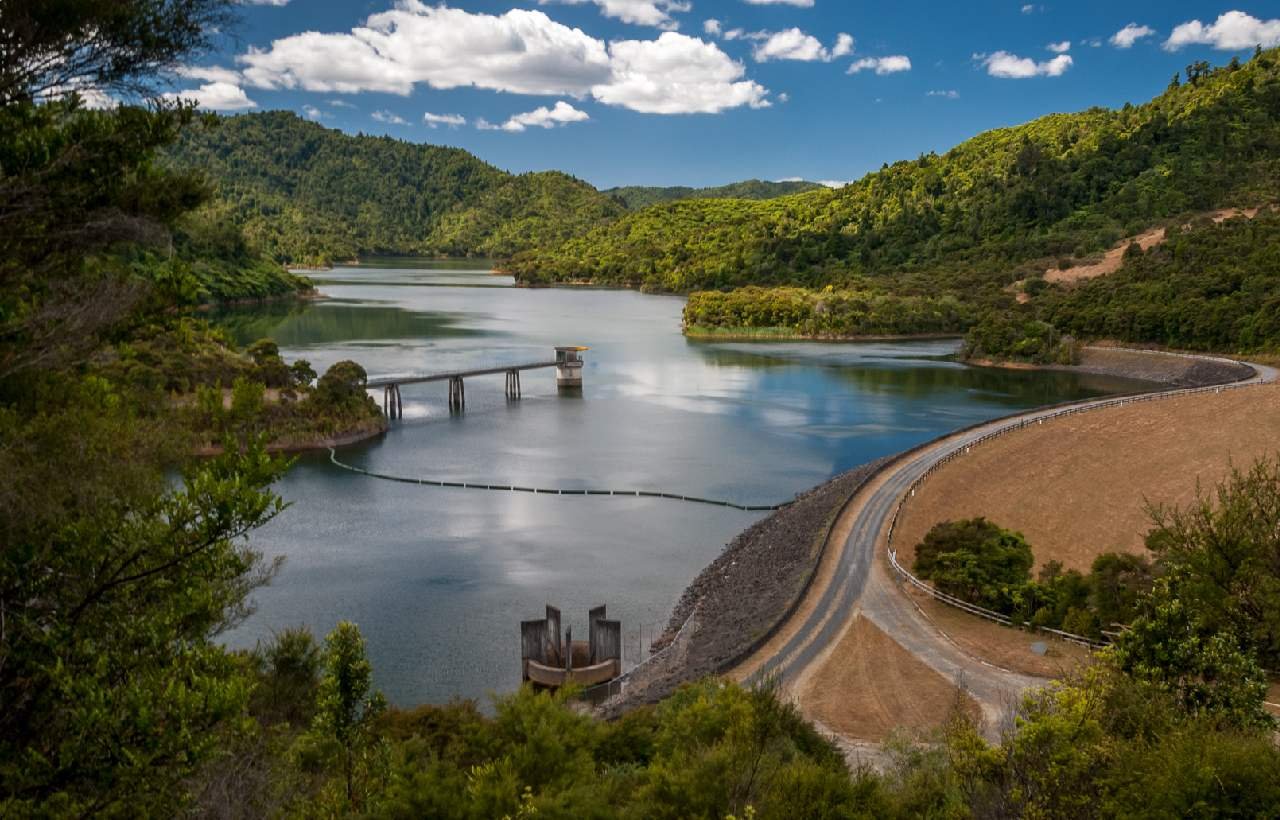
// 7.7 kilometres
// 2 hours
The Hunua Ranges Regional Park offers some great hiking near Auckland. There are several different tracks to choose from, with one of the highlights being the Wairoa Dam Lookout Loop.
Start from the carpark at this location and walk the loop anti clockwise. The track takes you through regenerating forest before reaching the junction for the Repeater Campground.
At that point the track starts to loop back around, with a lookout point about halfway back on the return leg.
You’ll then climb down to the Wairoa Access Road and walk back to the carpark.
Currently closed tracks
These walks are unfortunately closed at the moment, due to a combination of the weather events at the start of 2023 and kauri dieback closures.
Te Henga Walkway Hike

// 10 kilometres
// 3.5 hours one way
The Te Henga Walkway is one of the best hikes near Auckland.
It traces a rugged path from Bethells Beach to Muriwai, cutting through dense coastal brush bent back toward the hills by the force of the wind, and looping behind secluded bays. For coastal views and true west coast wildnerness, Te Henga is a top walk.
The challenge with this track is logistics. The start and end point are nowhere near each other, so you have to coordinate with another group to start at opposite ends and swap keys halfway, or walk the track as an out and back. It’s 10 kilometres one way, so out and back is a solid mission.
The other option is to walk in from each end on different days, which is what I go for. Even just walking for an hour before turning back will give you a good taste of this brilliant Auckland walk.
From the Bethells Beach/Te Henga end, you can make it to O’Neill Bay, one of my favourite West Coast beaches. From the opposite end, Te Waharoa Point is a good spot to aim for.
The track isn’t too difficult but it can be slippery, narrow and rutted in places, so wear good shoes.
Fisherman's Rock via White and Rose Tracks

// 7.6 kilometres
// 3.5 hours
This Auckland hike is a bit of a hidden gem. It can be tricky to find - head to the Marawhara Track in North Piha first. This is a short 10 minute walk to a small swimming hole.
From there, you can carry on walking on White’s Track, which leads you to the Roase Track Trailhead and Carpark. From there, you can walk down to White’s Beach and on to Fisherman’s Rock.
You can make the walk a loop by climbing back to North Piha via the Laird Thomson Track.
It’s a lot of joining up different tracks but it makes for a nice walk with good views!
Thanks for reading this far! I hope you’ve found some ideas for walks to try in Auckland.
If you’d like to explore more of the city, you might be interested in checking these out before you go:
Stock up on snacks before your Auckland day walk at the city’s best bakeries