21 of the best multi-day hikes in New Zealand — North & South Islands
New Zealand’s hut network make multi-day hiking accessible. These are some of my favourite trails.
New Zealand is a hut to hut hiking dream.
Instead of the ‘inn to inn hiking’ you might find in Europe, New Zealand has hut to hut hiking.
New Zealand has one of the best hut networks in the world. These range from basic shelters to 80-bunk lodges with flushing toilets and solar powered lights.
The whole country is criss-crossed with a spectacular track network, as well as the world’s most extensive hut network.
Add to that an incredible diversity of landscapes, from volcanic peaks to glaciers and coastal cliffs, and you have the ideal setting for hiking.
Still, I have a few favourite New Zealand hiking trails that stand out.
If you want adventure, these are some of the best overnight and multi-day hikes in both the North and South Islands.
Some resources that can come in handy for planning a hut to hut hike in New Zealand
DOC is the source of truth for most hikes in New Zealand, and their website has most of the information you need to plan a hike, including online topo maps.
A Bunk For The Night — For inspiration and an awesome coffee table book.
I have a deep and abiding love for New Zealand’s huts (we’re one of the best, if not the best, countries in the world for hut to hut hiking). You can read more about our huts in a story I wrote for National Geographic.
The biggest danger while hiking in New Zealand is the weather, so always check MetService weather forecast before setting out, and let someone know your plans.
You can check the weather in New Zealand’s national parks on NIWA
Plan my walk is a great app for walks and trails around New Zealand
When you’re in New Zealand, DOC visitor centres are great places to get information, weather updates, and maps.
I highly recommend hiking with a personal locator beacon (PLB) with you. If anything happens, to you or another person, you’ll be able to get help. You can often rent these from DOC visitor centres if you don’t have your own.
And a quick note on our Kiwi hiking slang
While some people refer to overnight hiking as backpacking or trekking, in New Zealand it’s most commonly known as ‘tramping’.
Tramping, trekking, backpacking and hiking all mean the same thing when referring to overnight hikes in New Zealand.
New Zealand has a strong outdoorsy culture, and many locals love to go tramping (or backpacking).
North Island hikes
Cape Brett Track - stay in a historic lighthouse keeper's hut

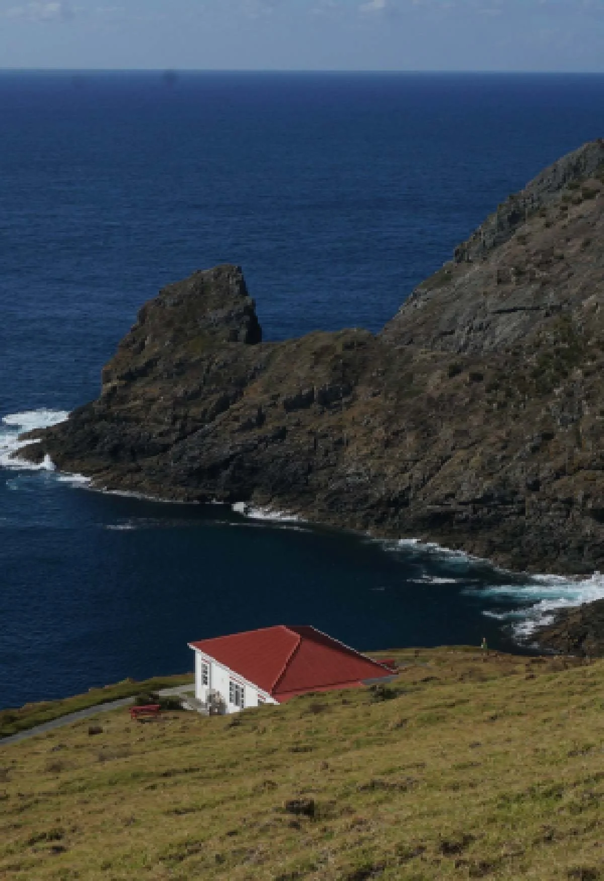

Cape Brett is one of the best overnight hikes in the North Island, but if you’re motivated you can also knock it off in a day.
I recommend staying the night in the hut, which is the old lighthouse keeper’s cabin, but you’ll have to book in advance as spots are limited and it’s a popular weekend hike.
I went on a Monday night and only shared with two other people though, so if you’re flexible you can make it work.
You can choose to catch a ferry out to Deep Water Cove, then walk to the hut, stay overnight (or turn around) and then hike back out to Oke Bay. Or vice versa — hike all the way out, then catch the ferry back from Deep Water Cove.
The Cape Brett hike follows a rocky peninsula out into the Bay of Islands, with spectacular views in all directions. It’s a rocky scramble in places, and you’re exposed to the Northland sun so it can be challenging.
One important thing to note is that there’s no potable water in the hut (although there is usually water for cooking). You’ll have to carry water with you, which means a heavy pack if you’re going overnight.
3. The Aotea Track - hike around the remote Great Barrier Island

// DOC’s Aotea Track Brochure
// 2-3 days
// Easy — the days are short if you take 3 days
The Aotea Track is a 2-3 day hike around Great Barrier Island.
Great Barrier Island is special for a number of reasons — it’s two thirds conservation land, free of invasive possums, and free of any large stores, including supermarkets.
The Aotea Track loops around the island and gives you the best views on the island.
The highlight is staying at Mount Heale hut, just below the peak of Mount Hobson, the highest mountain on Great Barrier Island.
Mount Heale Hut has spectacular views out across the Hauraki Gulf. The west facing balcony is perfect for sunsets.
I also loved walking through the regenerating kauri forests. Most of the oldest trees are gone, felled by an aggressive logging industry in the 1800s and early 1900s, but 150,000 kauri seedlings were planted between 1976-1987.
These younger trees have already reached an impressive size, and it’s pretty awesome to see their recovery.
While you’re on Great Barrier Island, make sure you visit Medlands Beach — it’s one of the prettiest beaches in the Auckland region.
4. The Pinnacles - climb to one of the most impressive peaks in the Coromandel Ranges
// 6 kilometres one way
// 3 hours to the summit
// Somewhat challenging — it’s all uphill
Hiking to the rocky summit of the Pinnacles gives you panoramic views of the Coromandel Peninsula.
From up on the summit, I can see all the way down to my mum’s farm close to Pauanui.
You could easily hike up to the Pinnacles and back in a day, but staying overnight in the hut means you get to take in the panoramic views at sunset and sunrise, if you get lucky with the weather.
Just note that this is a popular hike with an 80 bed hut — it might not be as tranquil an experience as you might like (that’s a lot of people sharing the same space, so it’s likely you’ll hear some snoring).
It’s popular with school trips so there’s a good chance it will be full of young teens when you go.
For more privacy, you can book a spot in the small campground below the hut.
The Tongariro Northern Circuit is another of New Zealand’s Great Walks (they aren’t called Great Walks for nothing — they really are some of the best multi-day walks in New Zealand).
Tongariro National Park is a UNESCO heritage area, one of only two in New Zealand, thanks to its rich biodiversity and cultural heritage.
The Tongariro Circuit is the best way to see the park. This trail loops through incredible volcanic landscapes.
You’ll see the famed emerald pools that made the Tongariro Crossing so famous, pass through golden tussock with volcanos rearing up in the distance, and see New Zealand’s only desert.
11. Queen Charlotte Track
The Queen Charlotte Track is one of New Zealand’s most accessible multi-day hikes.
The way the track is laid out, you can spend each night in a lodge (camping is also an option, but hot showers and food are more enticing) and have your pack shipped to each stop by boat.
This means you can walk the 3-4 day track with just a day pack, relaxing each evening in waterfront accommodation.
I did this hike in 3 days, 2 nights.
I stayed in a Basecamp Single Room at Ponga Cove Resort on the first night, and Treetops Backpackers (book over the phone) on the second night.
It was great having a hot shower at the end of each day — a significant upgrade from the standard DOC hiking hut.
The hike itself follows a ridge of land between Kenepuru and Queen Charlotte Sounds. You’ll walk past quiet bays and over native-bush clad hills, with views of the Marlborough Sounds the reward for your efforts.
The Marlborough Sounds are a uniquely beautiful part of New Zealand, and the Queen Charlotte Track is the best way to explore the area.
12. Abel Tasman Coast Track
// 60 kilometres one way
// 3-5 days
// Easy — the track hugs the coast so it’s mostly flat
The Abel Tasman Coast Track is one of New Zealand’s Great Walks. It’s a multi-day trek interspersed with campgrounds and huts, making it easy to walk as much or as little as you want in a day.
Highlights of the Abel Tasman track include the incredible golden beaches and calm waters which are perfect for swimming, especially after a hot day of hiking.
Most people start the walk in Marahau and end in Totaranui, from where you can catch a water taxi back to Marahau. If you walk right to the end of the track, the logistics are trickier, as you’ll be quite from from where you started.
You can also kayak sections of the track.
The further away from Marahau you can get, the better. You’ll reach more secluded and pristine beaches, while at the start of the track you’ll be sharing the track with plenty of others and the water isn’t as crystalline.
My favourite campsites along the track are Mutton Cove and Anapai Bay, close to the Golden Bay end — basically, the most remote ones.
Most people end their hike in Totaranui, so if you carry on past there you’ll be rewarded with emptier trails and campgrounds.
You can also walk sections of it as day walks, starting from either the Marahau end close to Nelson, or from the Golden Bay end.
13. Mount Owen Track
Heading up to the highest peak in Kahurangi National Park makes for an epic overnight hike.
I hiked in to the Granity Hut on the first day and headed up the peak first thing in the morning, before hiking out to the carpark again afterward.
Take care on the rocks leading up to the summit. There are some deep crevasses and if it’s cold enough, frost can make them slippery.
Fun fact | The unusual rock formations at Mount Owen served as a film location for Lord of the Rings. They were used for scenes of Dimrill Dale and Moria in the first LOTR trilogy.
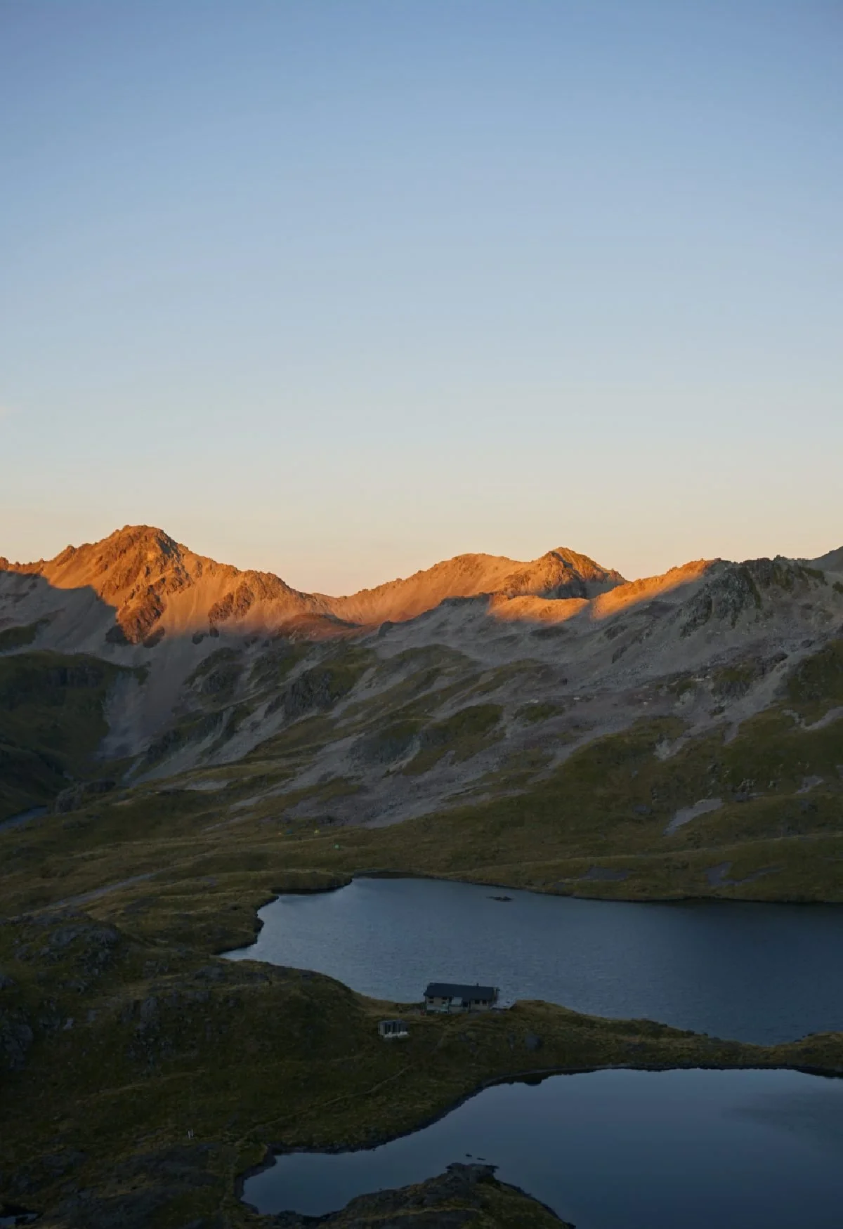
14. Roberts Ridge to Angelus Hut
// 12.2 km one way
// 6 hours
Angelus Hut might be my favourite hut in the South Island. It’s an absolutely stunning spot next in the high reaches of Nelson Lakes National Park.
The hut sits right next to an alpine tarn, surrounded by a ring of tussocked peaks.
The track in to the hut follows the Pinchgut track (which is a great day walk near Nelson) past the lovely little Bushline Hut, and carries on to Roberts Ridge.
On a clear day, the views from Roberts Ridge are absolutely spectacular. Rocky slopes fall away on both sides and you can see across the lakes and beech forests that Nelson Lakes National Park is famous for.
You’ll need to book the hut in advance, as it’s a popular destination. If you miss out on a bunk there is a campsite near the tarn, and you can also wild camp in the area around the hut.
You can hike in and out the same way, or head back to the carpark via Speargrass Hut, which makes for a nice lunch stop.
One important thing to note for this hike is that you need to take care with the weather. If there is snow, ice, or low visibility, the hike can be dangerous.
15. Liverpool Hut

// 15 kilometres one way
// 6 hours 30 minutes from Raspberry Flat
The West Matukituki Valley, in Mount Aspiring National Park near Wanaka, is one of my favourite places to hike in the South Island.
This is where you can find the Rob Roy Glacier day walk, as well as the hike up to Cascade Saddle.
There are two spectacular alpine huts to hike to from the Raspberry Flat Carpark — French Ridge Hut and Liverpool Hut.
Both are stunning red huts located above the treeline, reached by tough tracks which are a steep scramble through dense beech forest.
I love them both, but Liverpool Hut might just pip French Ridge on the scenic front, thanks to its view across the valley to Mount Aspiring — you can’t see the peak from French Ridge.
You can hike in and out to Liverpool hut in two days. The climb up to the ridge is a scramble in places, but hauling yourself up rocks and tree roots is part of the fun.
Make sure you book your spot in the hut, it’s only 12 spaces and getting more popular.
If you want to visit French Ridge hut as well, you can spend a night in Aspiring Hut, which is a cosy hut halfway back to the carpark.
16. Mount Brown Hut


// 10 kilometres out and back
// 2.5-3 hours up, 2 hours down
The tiny orange Mount Brown hut is an icon among the New Zealand hiking community. You’ll see it on DOC posters everywhere.
The hut sits high up above Lake Kaniere. The trail head is a 30-minute drive from Hokitika on the West Coast of the South Island.
From its vantage point high up above Lake Kaniere, Mount Brown hut has stunning views of the surrounding mountains and coastline.
That is, if you’re lucky to get clear weather — as this hike is on the West Coast, there’s a good chance you’ll get clouds.
I only saw a lot of cloud, but it was beautiful nonetheless and the hut itself is a cute spot to shelter from the elements.
The hike up is steep in places and it can be easy to lose track of the markers. The trail is managed by volunteers (not DOC) so it’s not as clearly signposted as other walks.
There are only 4 bunks in the hut, so it’s a good idea to take a tent up with you as well if you plan on staying the night — there are a couple of good flat areas near the hut where you can set up camp.
17. Welcome Flat Hut via the Copland Track
// 18 kilometres one way
// 7 hours
// Moderate
The Copland Track to Welcome Flat Hut is a seven-hour walk through spectacular West Coast scenery.
The track climbs gently through a river valley, with views of the water, beech forest, and surrounding mountains. While it’s not a difficult hike, it is long, so go prepared for a solid day of walking.
It’s worth it once you reach the hut, though.
The natural hot pools are a treasure, and one of the most spectacular places I’ve seen in New Zealand’s backcountry. They are as good as any hot pools you can visit.
You can soak in them then jump in the glacial river, for some awesome hot and cold immersion.
Kea hang around the pools and the hut, which is spacious and beautiful. You’ll need to book a spot in advance.
18. The Mueller Hut Track
// 5.2 kilometres one way
// 4 hours
The Mueller Hut is a stunning destination in Aoraki Mount Cook National Park.
Located at 1800 metres, the hut has incredible views of Aoraki/Mount Cook, the highest peak in New Zealand. You can also admire sheer rock faces, cliffs of ice, and the spires of the Southern Alps falling away into the distance.
The Mueller hut is very popular, so you’ll need to book a bunk well in advance if you want to stay overnight.
If the hut is fully booked, you can still make this a great (but long) day hike. There are some awesome budget accommodation options in Mount Cook Village, including the YHA hostel and the White Horse Hill DOC campground.
19. The Routeburn Track
// 33 kilometres
// 2-4 days
// Moderate (some climbs but a very well-maintained trail)
The Routeburn Track is one of the most accessible Great Walks of New Zealand.
It’s only 30 kilometres long, which means you can hike the trail in 2-3 days (or 4 days if you want to spread out the walking and enjoy the scenery).
The trail connects Mount Aspiring National Park and Fiordland National Park, so it’s a chance to see some of the most stunning wilderness areas of New Zealand.
The Routeburn is a one way hike starting (or ending) near Glenorchy and finishing up on the road to Milford Sound.
20. Kepler Track
// 3-4 days
// 60 kilometres
The Kepler Track is a Great Walk and one of the premier multi-day hikes in the South Island.
Starting near Te Anau, the trail runs through alpine peaks in Fiordland National Park before dipping back down to lakes and beech forest.
It’s nice and easy to organise, as the trail head is within walking distance of Te Anau (or a short drive) and the loop track means you don’t have to organise transport to and from the start/end points.
I hiked the Kepler in mid-October, just before the Great Walk season began.
That made it significantly cheaper, and I didn’t have to worry about fighting for a booking in the huts, but I did have poor weather across the alpine tops, and the views from the ridge are the highlight of the track.
21. The Hump Ridge Track
// 3 days
// 61 kilometres
The Hump Ridge Track is set to be New Zealand’s next Great Walk.
The three day loop walk covers epic terrain at the very bottom of the South Island. The track covers beach, forest and mountains.
One of the highlights of the Hump Ridge is a boardwalk which loops around limestone tors in the alpine tops. From up here, you get epic views of Fiordland, the Southern Ocean, and Stewart Island.
My favourite part of the Hump Ridge walk was swimming with Hector’s dolphins in a bay near Port Craig, on the coast.
There are a few different ways to experience the Hump Ridge Track:
A “Freedom Walk” where you hike the track and stay in shared bunk rooms at the Okaka and Port Craig Lodges
A Prime Package which offers more luxurious accommodations (you can opt for private rooms and hot showers)
A guided walk
What to pack for a multi-day hike in New Zealand
New Zealand weather is changeable, so you’ll need to pack layers, preferably in materials that are warm and quick to dry.
I recommend wearing proper hiking boots — I walked the Abel Tasman track in sneakers and lost two toenails.
Boots will be more comfortable, and keep your feet drier if it rains.
My multi-day hike gear list:
A sleeping bag (I use a RAB sleeping bag and it’s warm enough for most nights in New Zealand)
Two pairs of yoga pants/leggings
1 pair of merino track pants for wearing around the hut (although you won’t need these for summer hiking at lower elevations)
A Mons Royale puffer jacket for alpine or winter hikes
A Patagonia fleece for all seasons
3 pairs of woollen socks
2 long sleeved merino t-shirts
MSR stove
A titanium Snow Peak cup (600mls means it’s big enough for my morning coffee and evening meals)
Opinel pocket knife
You typically won’t need a water filter, as you can drink from most streams in New Zealand mountains. Huts generally have a boil water notice, but I rarely boil my drinking water and I’ve never had an issue.
Thanks for reading this far! I hope you found some inspiration for your next overnight hike in the North or South Island.
Before you go, you might like to check out my recommendations for day hikes around Auckland — you can walk through some spectacular landscapes within an hour of the city.